Showing posts with label * Map Cards. Show all posts

Tuesday, September 10, 2019

Russia: Map

The Russian Federation, commonly known as Russia, is the most extensive country in the world, covering 17,075,400 square kilometres (6,592,800 sq mi), more than an eighth of the Earth’s land area. Russia is a transcontinental country extending across the whole of northern Asia and 40% of Europe; it spans 11 time zones and incorporates a great range of environments and landforms.


Thanks to Andrey. Russia issued 12 definitive on Kremlin's in 2009. He has used one that shows Tobolsk Kremlin. The Tobolsk Kremlin  is the sole stone Kremlin in Siberia. It is located in Tobolsk, Tyumen Oblast, Russia.

Tuesday, May 21, 2019

USA: Galveston Islands.

Galveston Island is a barrier island on the Texas Gulf Coast in the United States, about 50 miles (80.5 km) southeast of Houston. The island is about 27 miles (43.5 km) long and no more than 3 miles (4.8 km) wide at its widest point.


Thanks to Mr Sergey

Thursday, March 7, 2019

Philippines: Manila

Manila, the capital of the Philippines, is a densely populated bay side city on the island of Luzon, which mixes Spanish colonial architecture with modern skyscrapers. Intramuros, a walled city in colonial times, is the heart of Old Manila. It’s home to the baroque 16th-century San Agustin Church as well as Fort Santiago, a storied citadel and former military prison.


Thanks to Ms Rachelle.

Sunday, August 5, 2018

Indonesia: Jakarta

Jakarta, officially the Special Capital Region of Jakarta, is the capital and largest city of Indonesia. Located on the northwest coast of the world's most populous island Java, it is the centre of economics, culture and politics of Indonesia, with a population of 10,075,310 as of 2014.


Thanks to Ms Anggara.

Wednesday, February 7, 2018

Thailand: Phuket

Phuket is one of the southern provinces (changwat) of Thailand. It consists of the island of Phuket, the country's largest island, and another 32 smaller islands off its coast. It lies off the west coast of Thailand in the Andaman Sea.


Thanks to my cousin Laky and his wife Radhika fro sending this from Phuket.

Wednesday, December 27, 2017

South Africa: Map

South Africa, officially the Republic of South Africa (RSA), is the southernmost country in Africa. It is bounded on the south by 2,798 kilometres (1,739 mi) of coastline of Southern Africa stretching along the South Atlantic and Indian Oceans;on the north by the neighbouring countries of Namibia, Botswana, and Zimbabwe; and on the east and northeast by Mozambique and Swaziland; and surrounds the kingdom of Lesotho.


Thanks to Dr Kiran Acharya.

Saturday, October 14, 2017

Turkey : Map

Turkey, officially the Republic of Turkey is a transcontinental country in Eurasia, mainly in Anatolia in Western Asia, with a smaller portion on the Balkan peninsula in Southeast Europe. Turkey is bordered by eight countries: Approximately 70–80% of the country's citizens identify themselves as ethnic Turks. Kurds are the largest ethnic minority group, making up approximately 20% of the population. Ankara is the capital while Istanbul is the country's largest city and main cultural and commercial centre.


Thanks to Ms Seema.

Sunday, April 23, 2017

Austria: Salzkammergut

Salzkammergut is an Austrian region of lakes and Alpine ranges near Salzburg. In the south, the pastel houses of Hallstatt crowd the shore of Lake Hallstatt, which is ringed by mountains. Above town, exhibits at Salzwelten illuminate an underground salt mine’s thousands of years of history. Natural ice formations fill the Ice Cave on Dachstein Mountain. Nearby, 5 Fingers lookout offers sweeping lake and Alpine views.


Thanks to Dr Kiran Acharya

Sunday, June 26, 2016

Marshall Islands: Map

The Marshall Islands are a sprawling chain of volcanic islands and coral atolls in the central Pacific Ocean, between Hawaii and the Philippines. In the northwest, Bikini Atoll’s largely undisturbed waters, used as a ship graveyard after World War II, are now a popular wreck dive site. Near Majuro Atoll, which holds the islands' capital and largest settlement, the coral reef at Kalalin Pass teems with marine life.


Thanks to Ms Kim Makoi

Tuesday, June 7, 2016

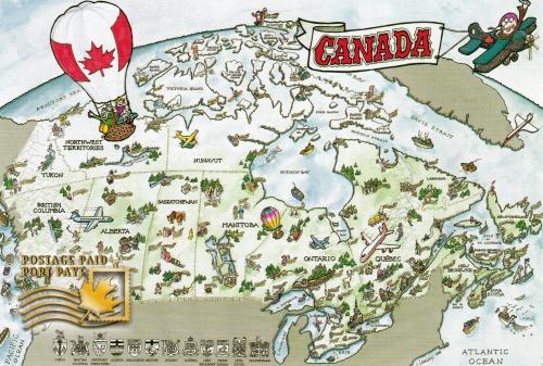
Canada: Map

Canada, stretching from the U.S. in the south to the Arctic Circle in the north, is filled with vibrant cities including massive, multicultural Toronto; predominantly French-speaking Montréal and Québec City; Vancouver and Halifax on the Pacific and Atlantic coasts, respectively; and Ottawa, the capital. It’s also crossed by the Rocky Mountains and home to vast swaths of protected wilderness.


 Thanks Ms Paulette.

Monday, March 7, 2016

Netherlands: Old African Map

This postcard shows old map of Northern African nations.


Thanks to Ms Yuonne. This card was missent to Jakarta.

Friday, March 4, 2016

British Virgin Islands: Map Card

The British Virgin Islands (BVI), officially the Virgin Islands, is a British overseas territory located in the Caribbean to the east of Puerto Rico. The islands make up part of the Virgin Islands archipelago; the remaining islands constitute the U.S. Virgin Islands and the Spanish Virgin Islands.


Thanks to my friend Mr Jitender Singh who was visiting these Islands

Wednesday, March 2, 2016

New Zealand: Map

New Zealand is an island country in the south western Pacific Ocean. The country geographically comprises two main landmasses – that of the North Island, or Te Ika-a-Māui, and the South Island, or Te Waipounamu– and numerous smaller islands. New Zealand's capital city is Wellington, while its most populous city is Auckland.


Thanks to Mr Alex

Saturday, January 23, 2016

China: Map

China, a communist nation in East Asia, is the world’s most populous country. Its vast landscape encompasses grassland, desert, mountain ranges, lakes, rivers and 14,500km of coastline. Beijing, the ancient capital, mixes modern architecture with historic sites including sprawling Tiananmen Square. Its largest city, Shanghai, is a skyscraper-studded global financial center. The iconic Great Wall of China fortification runs east-west across the country's north.

Postcard 1


Thanks to Ms Crystal Lan.
Postcard 2


Thanks to Ms Tian Ziyi of China.

Tuesday, July 14, 2015

Panama: Map

Panama, officially called the Republic of Panama, is a country in Central America situated between North and South America. It is bordered by Costa Rica to the west, Colombia to the south east, the Caribbean to the north and the Pacific Ocean to the south. The capital and largest city is Panama City, whose metro area is home to nearly half of the country's 3.6 million people.


Thanks to Ms Blanca Brown.

Friday, November 7, 2014

Ireland: Map

Ireland is an island in the North Atlantic to the west of Great Britain, from which it is separated by the North Channel, the Irish Sea, and St Georges Channel, and after which it is the largest island of the British Isles archipelago. It is the third-largest island in Europe and the twentieth-largest island on Earth.  Ireland is the only country in the world that has a musical instrument – the harp – as its national symbol. The oldest known harp in existence is housed in Trinity College, Dublin. It dates back to at least 1300.


A Postcrossing meetup card. Thanks to Maggei, Kodzos, Goldcrest, Xtlera, Ned44440, Jr11577

Sunday, July 20, 2014

Iceland: Map

Iceland is an island of 103.000 km2 (39,756 sq.miles), about one-third larger than Scotland or Ireland. Its highest peak, Hvannadalshnjúkur, rises to 2.119 m and over 11 per cent of the country is covered by glaciers, including Vatnajökull, the largest in Europe.


My first postcard from Island. Thanks to Soea who was visiting Iceland.

Friday, July 18, 2014

Finland: Map

Finland is a Nordic country in Northern Europe. It is called " Land of the midnight sun " because in June and July the sun shines all day and all night. It is also called "land of thousand lakes". The amount you get fined for speeding in Finland depends on the amount you earn. There are no public payphones in Finland. While driving in Finland you must keep your headlights on all the time.


Grenada: Map

Grenada is an Island nation in the Caribbean. It is also called "Island of Spices" because of the production of Nutmeg and Mace crops. Its national bird is Grenada Dove which is critically endangered. St George is its capital.


Thanks to my uncle Dr Krishanand Bhandarkar who was visiting Grenada.

Sunday, July 13, 2014

Canada: The Great Lakes

The Great Lakes are Michigan, Superior, Huron, Eire and Ontario. They form the largest group of fresh water lakes in the world. they are interconnected and joins the Atlantic Ocean through the Saint Lawerence Seaway.